St. Gallen is refining its vision for the future of Lerchenfeld
In the west of St. Gallen, Lerchenfeld is set to become denser, taller and more diverse over the next two decades. The new development strategy links additional residential and commercial space to the future Bruggen-Haggen dual railway station and to new green spaces and footpaths.
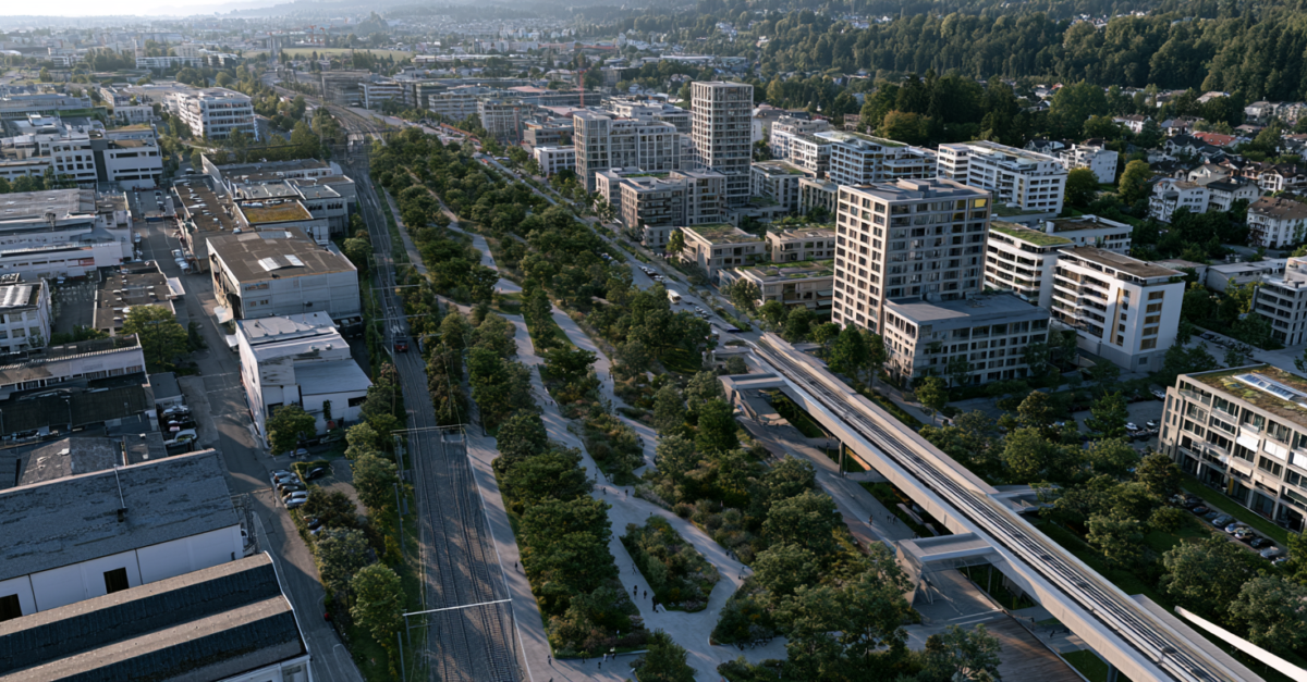
In the west of St. Gallen, the Lerchenfeld is not simply to be densified, but reorganised. The development strategy now on the table combines additional work and residential space with a framework of public open spaces comprising green corridors, paths and square-like connections. This is particularly relevant for property development because it means the city is establishing an early framework to guide rezoning, local development plans and subsequent site developments.
The core principle remains clear: Lerchenfeld is to remain primarily a commercial area in future, whilst at the same time accommodating significantly more residential use. Based on the figures provided in the input document – currently around 5,000 square metres of residential space and 60,000 square metres of commercial space – the city envisages a significantly higher potential for the area, which covers around ten hectares. Higher densities and building heights are explicitly part of the strategy.
The railway station as the driving force
According to available information, the city regards the future Bruggen-Haggen twin station as an infrastructural catalyst for the area. The development masterplan for the wider station area, published in 2025, refers to an additional floor area potential of around 80,000 square metres and describes the merger of the stations as a catalyst for an urban area combining workplaces and housing. The launch of procedures for rezoning to priority zones is planned for 2026, and the implementation budget for the station is to be submitted to the city council by the end of 2026.
This brings Lerchenfeld into a phase prior to the actual project planning, which is often crucial for property owners and developers. Those who own land in this corridor will enjoy greater planning certainty, but must at the same time be prepared for coordination across different plots. The city is not promoting isolated individual buildings, but rather a coordinated development framework.
Greater density, but not just through height
The proposal mentions possible building heights of up to 45 metres and, in exceptional cases, higher. This is in line with the direction set out in the official master plan, which envisages varying proportions of residential use, densities and heights depending on the sub-area. At the same time, the urban planning benefits do not lie solely in additional storeys. Crucial factors include the connection to the new railway station, a multifunctional public space between the buildings, and a continuous green space along the waterways.
It is precisely this combination that is central to the development of the site. The area is not only intended to accommodate more usable floor space, but also to be perceived as a cohesive neighbourhood and work environment. For future investments, this means that the quality of the ground floors, access routes and the use of open spaces are likely to become just as important as floor area ratios and building heights.
Local planning takes shape
According to publicly available information, the vision is being incorporated into the ongoing local planning review. At the same time, the city is prioritising individual rezoning procedures. This is increasing the pressure to swiftly translate spatial objectives into legally robust planning instruments. Whether the ambitious timetable can be met, however, continues to depend on political decisions and potential objections. For the market, nevertheless, the direction has been set: Lerchenfeld is being developed as a mixed-use area in the west of St. Gallen, with the railway station as the catalyst and with significantly higher standards regarding density, open space and cooperation.