Transparency in three dimensions – How geodata can help the property industry
Digital city models and geodata offer the property industry new opportunities. Digital tools such as the 3D viewer MapBS 3D, the PLR cadastre and the property information of the canton of Basel-Stadt can help to make planning and investment in property more efficient and transparent - they have long since become more than just technical gimmicks.
Densification, climate adaptation and increasing regulatory density pose new challenges for the property industry. At the same time, digital geodata opens up a holistic view of space. With the 3D viewer MapBS 3D, the PLR cadastre and property information, digital tools are available in the canton of Basel-Stadt that help owners, developers and investors to sharpen their view of the canton and its properties.
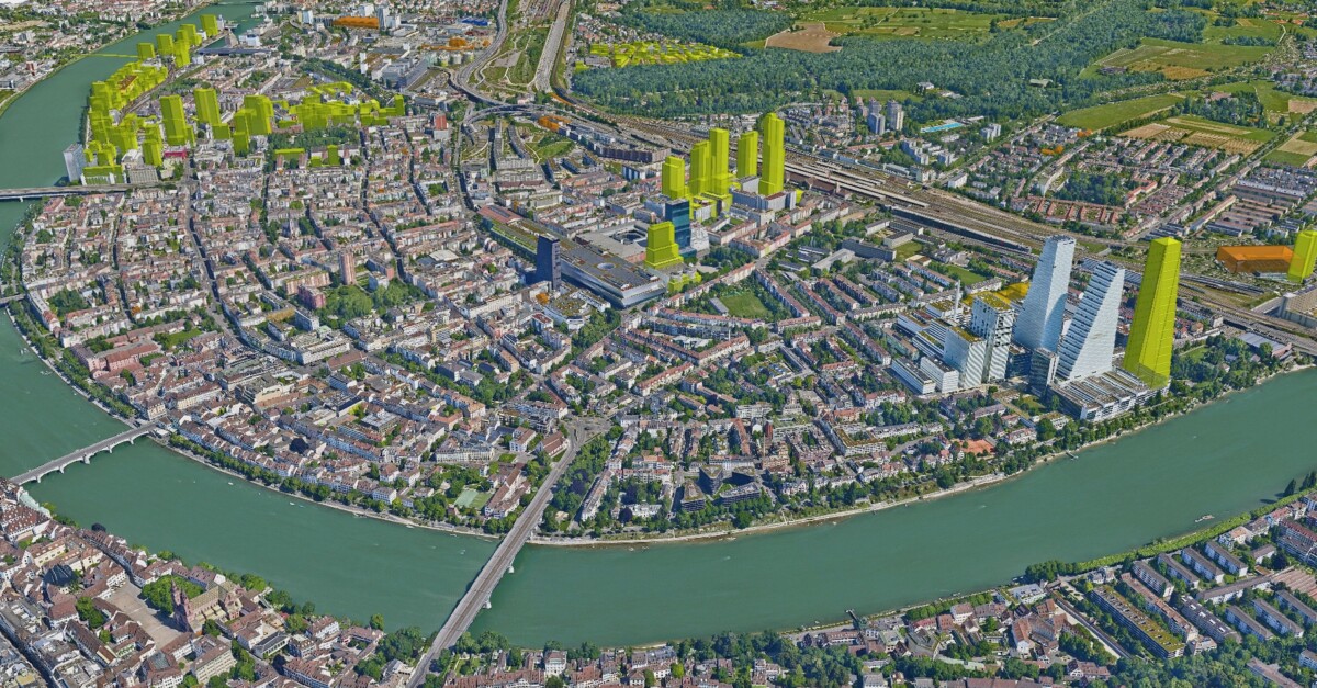
MapBS 3D – City and buildings as digital twins
What was previously only recognisable on plans can now be experienced in three dimensions in the browser:
– Basel as a digital 3D city model with buildings
buildings, terrain and trees.
– 3D aerial images and oblique aerial images for a
photorealistic view of the canton.
– The buildings can be filtered by height, for example,
and the data can be freely obtained and
integrated into customised applications.
– The toolbox can be used, for example, to simulate shading over the course of the year or visibility axes.
This makes a location spatially comprehensible. Whether an extension is realistic, how a new building fits into the silhouette or which visual axes are affected – initial answers are just a few clicks away.
You can quickly recognise how a property fits into the urban context and where potential lies dormant. This makes MapBS 3D a valuable tool – not only for planners, but also for decision-makers.
The PLR-cadastre – Legal certainty at a click
Anyone who develops or acquires must know what applies. The PLR-cadastre – the abbreviation stands for public-law restrictions on ownership – bundles relevant specifications for a property: building zones, protected areas, noise or water protection, etc.
In Basel-Stadt, the cadastre currently covers over twenty subject areas, available online and also as a PDF extract. It is always up to date. This allows risks to be recognised at an early stage and legal framework conditions to be checked efficiently – an advantage that should not be underestimated in times of complex planning processes.
What else is possible?
If PLR topics are superimposed in MapBS 3D using the “Add layer” tool, a digital decision space is created.
Other interesting topics can also be found in the cantonal WebGIS MapBS. There you can use the “Property information” tool to call up information on a property and its buildings directly. The same information can also be automatically integrated into your own applications using an API.
All of this can be used, for example, to check whether a building intention conforms to the zoning plan or whether noise might make residential use unfavourable. This creates clarity and avoids misunderstandings. In this way, complex knowledge becomes spatially visible and it is easier to recognise location qualities, risks and scope for development.
What is planned for the future?
With twinbs, the Canton of Basel-Stadt wants to make geoinformation even more transparent and reliably accessible in the future. The full potential of spatial data is to be utilised. The Geoinformation Centre regularly collects feedback from users. Anyone with questions about MapBS 3D, the PLR cadastre or geodata in general is welcome to contact them directly.